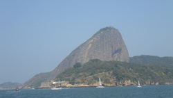
 Sugar Loaf in Guanabara bay, Rio de Janeiro We stayed only 72 hs in Madeira and on Friday August 10th at 1630 we started again. This leg was very tactical! We had to cross the equator, where there is always a band of light winds known as the doldrums. This band is usually located between 5 and 15 degrees north and it oscilates. The trick is to minimize the time spent in this area. If you are sailing south, you want to cross the doldrums in the region where it is moving north. The whole fleet stayed together heading south, passing west of the Canary Islands. The next set of islands was Cape Verde, located just off the coast of Africa at latitude 15 degrees north. This is where the fleet spread. You can either sail west of Cape Verde, through the islands or east of them, along the coast of Africa. Traditionally the doldrums are narrower west of Cape Verde. If the wind is right, there can be a funnel effect through the islands, speeding up the passage. However there is a risk of the wind dying and the boat getting stuck in a big wind shadow due to the islands mountains. During summer there is the phenomena of the "Africa monsoon"; due to the Sahara heat, there is a steady breeze blowing onshore along the coast, and this can favor a route east of the islands. There are a lot of factors at play when making the route decision. Every morning all the boats receive a file via email called GRIB. This is a data file with wind forecast in our area for the next 5 days. It is based on measurements and metereological models and it is freely available on the internet, produced by NOAA (National Oceanic and Atmospheric Administration). After studying the file we reached the conclusion that sailing east of Cape Verde, along the african coast, would be the best option. We were getting good wind due to the monsoon and it was forecasted light winds west of the islands. The rest of the fleet headed west while we were the only boat that kept heading south. We dropped positions on the fleet and people started wondering where we were going. We had good wind and we were confident that our strategy would pay off! The plan was to sail south until the latitude of Dakar in Senegal (10 degrees North) and then start heading southwest. The whole fleet would be stuck in a hole while we would climb up to the top. Well, that was the plan on paper, but in reality things were different. Our strategy depended on the rest of the fleet being stuck in light winds while we would get stronger winds; that would compensate the additional miles that we had to sail by going down the coast. However the GRIB files are not 100% accurate. What happened is that the wind filled up fron the north over Cape Verde and 3 boats, Gold Coast, Singapore and Welcome to Yorkshire, benefited from the funnel effect; they got a boost ahead of us! To make things worse, we hit some light wind during one day and one night. We were now in 4th place. There is an old sailing tradition of comemorating when crossing the equator for the first time. You make a ceremony in honor of Neptune and have a drink. We did a ceremony on the boat where Loyd dressed as Neptune, Victoria as Neptunes's wife and Sue as a mermaid. It was very funny! As a passing ritual 3 of us shaved our heads, including me! Short hair is much easier to deal with on a long voyage on a boat. After the equator we passed close to Penedos de São Pedro e São Paulo and the arquipelago of Fernando de Noronha, but we were too far to see them. We got close to the coast of Brazil around Recife, then we sailed down the coast 200 NM offshore. It was easy sailing, beam reaching, sunny and warm. It was the final stretch to Rio! At the southern part of Bahia, close to Abrolhos, we saw lots of whales; mothers and calves, breaching, swimming close to the boat. During winter these whales migrate from the southern ocean to the coast of Brazil to breed. It was a really cool sight! We saw the shore when we got 5 NM off Cabo de São Tomé, north of Campos bay. That night a low pressure system approached us from the south and we had rough seas and winds of 30 knots overnight. It was just like the storms in the Bay of Biscay! The last rought patch before arriving in Rio. On the next day the sky was cloudy and the wind was around 15 knots. The next and final waypoint was Cabo Frio, marked by a big rock, where the coast turns west. It is located 70 NM from Rio. After turning the cape, we sailed upwind and at night we started our approach to the entrance of Guanabara bay.
0 Comments
Leave a Reply.Archives
March 2014
Categories |
